


2024-12-16_07h46m43_randonnee-a-charousse

veroarvinberod
User
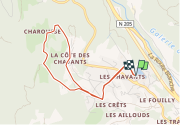

Length
4.6 km

Max alt
1253 m

Uphill gradient
245 m
Km-Effort
7.8 km

Min alt
1010 m

Downhill gradient
245 m
Boucle
Yes
Creation date :
2024-12-16 06:46:43.821
Updated on :
2024-12-16 06:46:45.266

FREE GPS app for hiking
 SityTrail
IGN / Geographical institutes
SityTrail Plus
The world is yours!
About
Trail of 4.6 km to be discovered at Auvergne-Rhône-Alpes, Upper Savoy, Les Houches. This trail is proposed by veroarvinberod.
Positioning
Country:
France
Region :
Auvergne-Rhône-Alpes
Department/Province :
Upper Savoy
Municipality :
Les Houches
Location:
Unknown
Start:(Dec)
Start:(UTM)
327888 ; 5084860 (32T) N.
Comments